Amini closes $4m Seed Funding Round led by Salesforce Ventures and Female Founders Fund

|
Kate at the TIME100 Africa Summit in Kigali November 2023 (1) (Source: Amini | 1 year ago) |
Image |

|
Kate at the TIME100 Africa Summit in Kigali November 2023 (2) (Source: Amini | 1 year ago) |
Image |
|
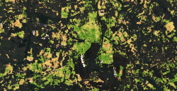
A map of part of Elgeyo Marakwet County in Kenya, showcasing the vegetation health of maize farms. The color coding ranges from brown to green, with green indicating the healthiest vegetation, brown the least healthy, and yellow as intermediate (Source: Amini | 1 year ago) |
Image |
|
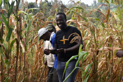
Our Geospatial Analyst demonstrating to Mr. Martin, a Kenyan farmer, specific areas of his corn farm that were affected (1) (Source: Amini | 1 year ago) |
Image |
|
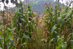
A view of Mr. Martin's corn farm, illustrating the practical impact of our data analysis on local agriculture (Source: Amini | 1 year ago) |
Image |
|
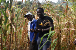
Our Geospatial Analyst demonstrating to Mr. Martin, a Kenyan farmer, specific areas of his corn farm that were affected (2) (Source: Amini | 1 year ago) |
Image |

|
Kate Kallot, CEO and Founder, Amini (Source: Amini | 1 year ago) |
Image |